Mammoth Lakes Greater Region 1:146K on Canvas
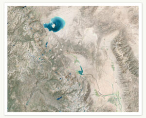 This extraordinary 44″x36″ topographic art captures the beauty of the greater Mammoth Lakes, California region like never before. This museum-quality fine art print showcases the stunning Sierra Nevada in unprecedented detail, spanning from Yosemite’s Tuolumne Meadows to the White Mountains and from just below Bridgeport past Bishop to just above Big Pine.
The map’s incredible 3D shaded relief brings every peak, valley, and ridge to life with remarkable depth and clarity. Printed at 2400×1200 DPI on fine art grade canvas with premium Canon inks, this map reveals intricate details including 250-foot index contours and 50-foot contours, detailed land cover, sections of Pacific Crest and John Muir Trails, hydrography, detailed road networks and more.
The massive coverage area includes Mammoth Lakes, June Lake, Mono Lake, Lee Vining, Bishop, and countless alpine treasures. Perfect for outdoor enthusiasts, local residents, and anyone who cherishes the Eastern Sierra, this map serves as both reference and a stunning piece of wall art. Each label is carefully placed, with major landmarks visible from a distance with fascinating details that reveal themselves upon closer inspection.

Mammoth Lakes 1:40K Wall Map
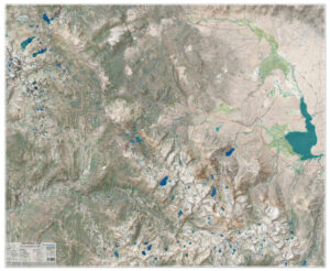
This 44″x36″ topographic wall map captures the Mammoth Lakes, California region and the surrounding Sierra Nevada in extraordinary detail. From Mount Ritter to Crowley Lake, the 3D shaded relief brings every peak, valley, and ridge to life with remarkable depth and clarity.
Printed at 2400×1200 DPI on durable, water-resistant synthetic material with premium Canon pigment inks, the map reveals 50-foot contours with 250-foot index contours, detailed land cover, sections of the Pacific Crest and John Muir Trails, hydrography, and an extensive trail and road network.
Coverage includes Mammoth Lakes, Mammoth Mountain, June Mountain, Duck Lake, Devil’s Postpile, the Silver Divide, over 10 hot springs, and countless alpine treasures. Labels are carefully placed with 7.5-minute, 1:24,000 USGS-level detail.
Both a functional reference and a striking piece of wall art, this map is perfect for outdoor enthusiasts, local residents, and anyone who cherishes the Eastern Sierra.
June Lake & Mono Lake 1:40K Wall Map
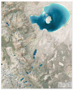
This 36″x44″ topographic wall map captures the June Lake and Mono Lake, California region and the surrounding Sierra Nevada in extraordinary detail. From June Mountain to Mono Lake, the 3D shaded relief brings every peak, valley, and ridge to life with remarkable depth and clarity.
Printed at 2400×1200 DPI on durable, water-resistant synthetic material with premium Canon pigment inks, the map reveals 50-foot contours with 250-foot index contours, detailed land cover, sections of the Pacific Crest and John Muir Trails, hydrography, and an extensive trail and road network.
Coverage includes June Lake Loop, Mono Lake, Lee Vining, Tioga Pass, Lundy Lake, Mount Lyell and countless alpine treasures. Labels are carefully placed with 7.5-minute, 1:24,000 USGS-level detail.
Both a functional reference and a striking piece of wall art, this map is perfect for outdoor enthusiasts, local residents, and anyone who cherishes the Eastern Sierra.